


Sheffield and Tinsley Canal
Connecting Sheffield by water

I recently took a look at the various efforts to connect Sheffield to the Midland Railway in the mid-nineteenth century, but even earlier there was a far longer process that eventually connected Sheffield by water to local trade routes - and by extension to the North Sea and beyond. The city could scarcely be any further away from the nearest coastline, and it took over a hundred years to complete a connection to the sea that was first seriously mooted back in the 1690s. During the eighteenth century the River Don (or Dun) was gradually made navigable with four ‘River Dun Navigation Acts’ being passed into law in 1725, 1726, 1732, and 1739, making possible the improvements necessary to allow trading traffic through. The navigable portion of the Don was extended as far as Rotherham by 1740, and then to Tinsley in 1751 - Sheffield was coming ever closer to being connected by water to the world.
When river traffic reached Tinsley the River Don Company maintained a road that linked the Tinsley wharf with the town centre, but plans continued to make a final link in the chain by water. Whilst businesses in the old town wanted to be connected beyond the area (the cutlers company was one of the main movers behind the scheme) there were also powerful interests rejecting the various plans. The Duke of Norfolk’s coal mines would potentially lose their large share of the Sheffield market when any canal was made. An earlier plan had the canal’s route going to the north of the river, but the Norfolk estate’s financial backing ensured that a route to the south was agreed on. That plan also included the ‘Greenland Arm’, a branch of the canal that linked the waterway with the Duke’s Tinsley Park collieries near Darnall. This long-closed (and now disappeared) waterway ran alongside the present day Greenland Road.

The 1815 Fairbank plan of the Sheffield and Tinsley Canal route
The Sheffield Canal Act was passed by Parliament in June 1815 and a year later the foundation stone was laid. On February 22nd 1819 the new canal was opened, with huge crowds watching the first boats travel down it. The canal ran four miles from Tinsley to Sheffield, and featured several interesting pieces of infrastructure along the route. Surely the most remarkable of which is the wonderful Worksop Road Aqueduct. Constructing the canal was a lot of hard work, and no more so than here where the water is carried over the road, and out of sight of people passing below. It really is a great structure, like the canal now over two centuries old, and just as the water is hidden from the road so is a beautiful stretch of the towpath above. It is such a Sheffield thing that you can view both the industrial and green aspects of the beauty of the city in the same place - if there were a ‘Seven wonders of Sheffield’ this would certainly be one in my eyes.
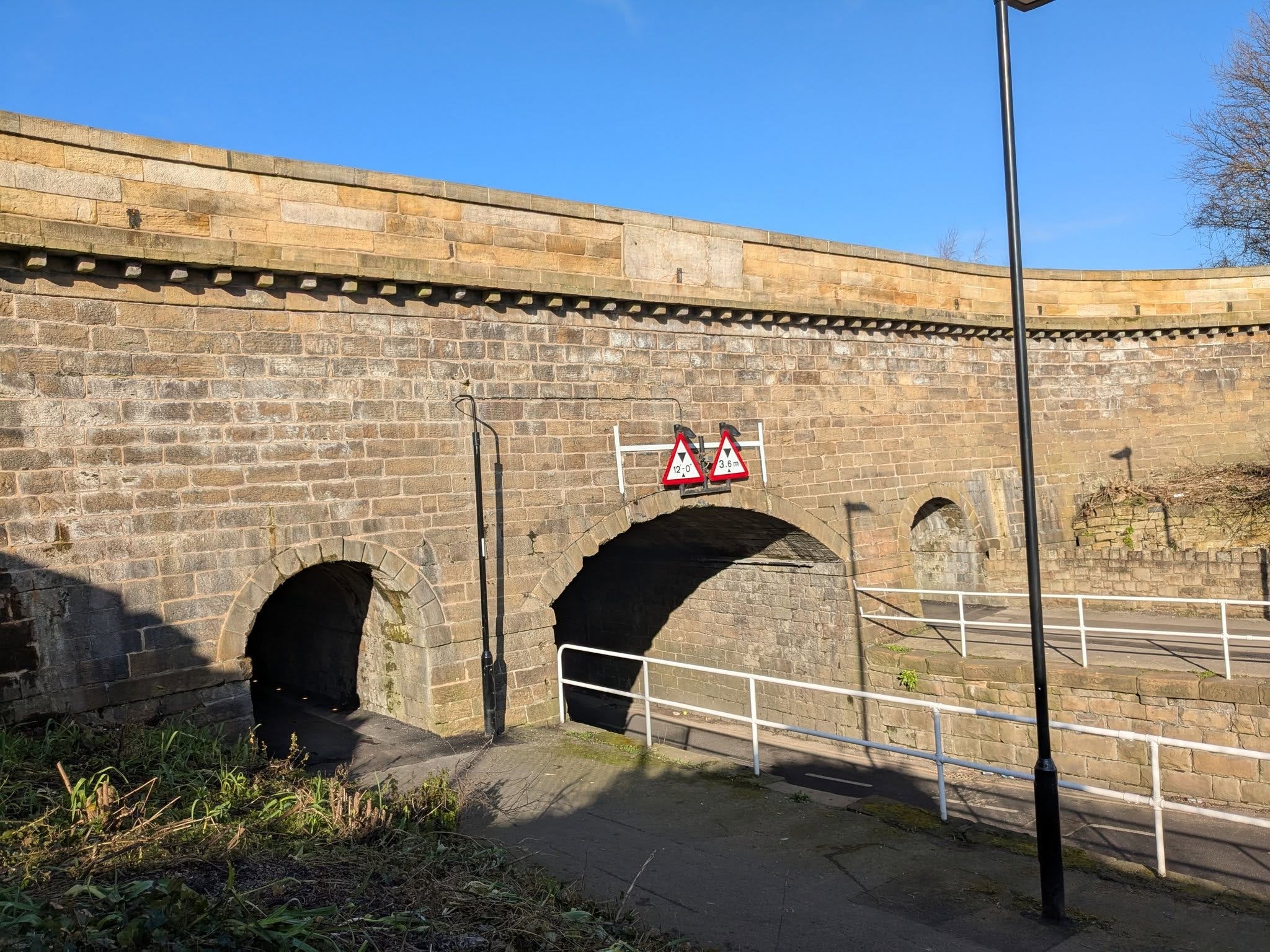
Worksop Road Aqueduct
Whilst that spot sees the canal cross the road, there are several roads in the area that cross the canal. Some are modern road bridges today; Broughton Lane, Coleridge Road, Shirland Lane, Staniforth Road - however there are two original bridges from 1819 surviving at Cadman Street and Bacon Lane. I assume that those two roads are considered able to operate in the modern day with the old narrow bridges, whereas the others needed upgrading as time went by and traffic increased. There are many bridges of similar age carrying busy roads over Sheffield’s rivers, especially along the Porter Brook. The two canal bridge survivors are particularly attractive, partly because we can walk under them to fully appreciate their construction. Whatever the reason for their survival they greatly improve the view and feel when walking along the towpath - and help keeping alive a connection with the canal’s origin story.
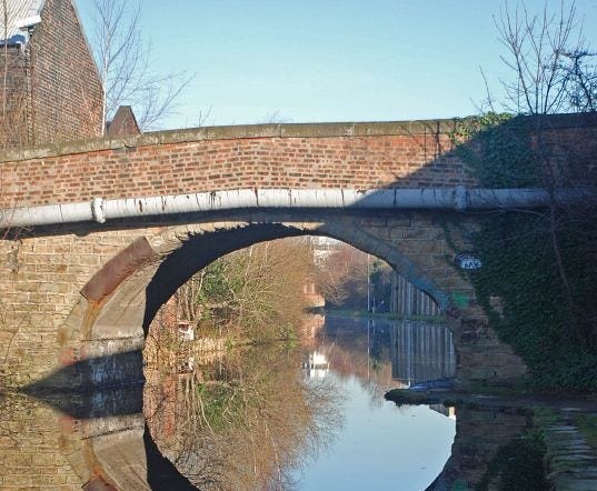
Bacon Lane Bridge
The Sheffield and Tinsley Canal was built somewhat late in the canal era, and not long before the railway era began in earnest. Sheffield’s first passenger station, connecting the town with Rotherham and therefore the Midland Railway, opened at the end of the Wicker in 1838. The new line used an adjacent route to that of the canal through the Don Valley. These days the canal closely interacts with the Supertram network in several places, but in the past that relationship was with the railway network. Stood next to the aqueduct was the original Attercliffe Station which closed in 1927, and part of the station structure, including a bricked up passenger subway, can still be seen from the towpath on the opposite side of the water.
Sheffield had an extensive rail network; not just passenger lines and stations, but freight lines and goods yards too. Much of this network was close to the canal basin; the Bridgehouses and Wicker goods yards, Sheffield Victoria Station, and more. The basin itself was host to the Park Goods Yard (sometimes referred to as a station) which was formerly housed in the buildings that are now home to bars and cafes alongside the moored barges. On the opposite side of the water, alongside Blast Lane, are two stone piers which have been decorated to celebrate the canal’s bi-centenary in 2019, but which were originally there to carry the railway line across the canal to the goods yard. Pictured below is a superb shot of the canal basin in late Victorian times, which not only gives a taste of how busy the river trade was, but also shows rail freight trucks on the top of the former goods yard arches.
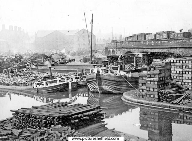
The canal basin and Park Goods Yard in 1887
In the nineteenth century there were also colliery branches and tramroads that met up with, or crossed over, the canal. There remain two, possibly three, places where some evidence survives. Near the Tinsley end it is possible to trace the remains of the old Peacock Bridge, which carried wagons over the canal from Tinsley Park collieries. On the towpath alongside Lumley Street you can still see the abutment of the bridge that carried the Nunnery Colliery branch railway over to Salmon Pastures coal yard. This was also the spot where from 1830 to 1870 a tramroad used to run coal down from the Manor pits to the town coal yard, which was sited next to the canal basin. Next to the historic Cadman Street bridge still stands Canal Works, which was built just a decade after the canal was opened. The 1855 Ordnance Survey map shows the tramroad line running right along the edge of the building, and intriguingly there appear to be two sets of rails still sticking out from the yard! I don’t know whether these are tracks from the pre-1870 tramroad - but they are in exactly the position where the line ran.
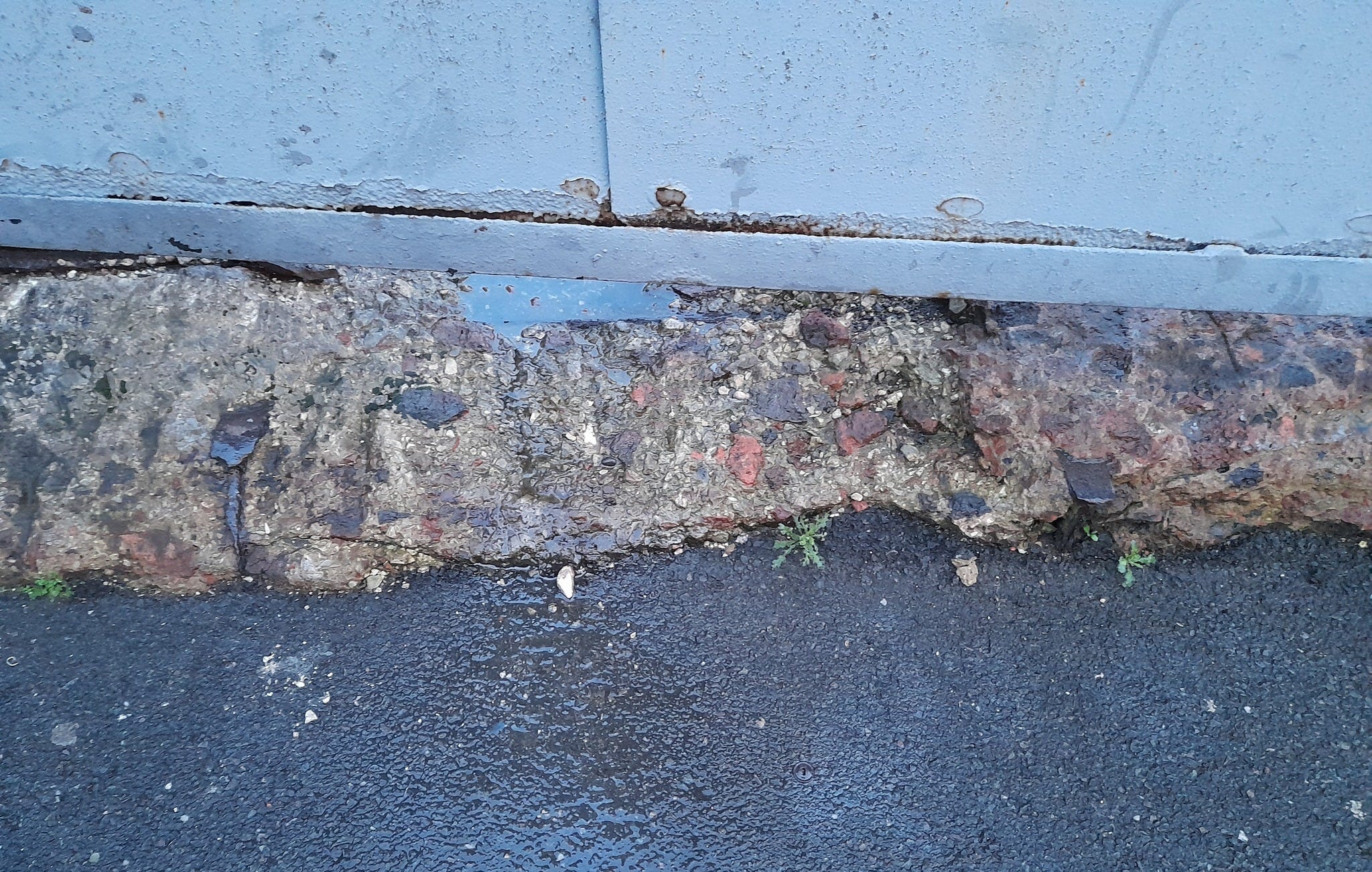
One of the sets of rails by Canal Works on Cadman Street
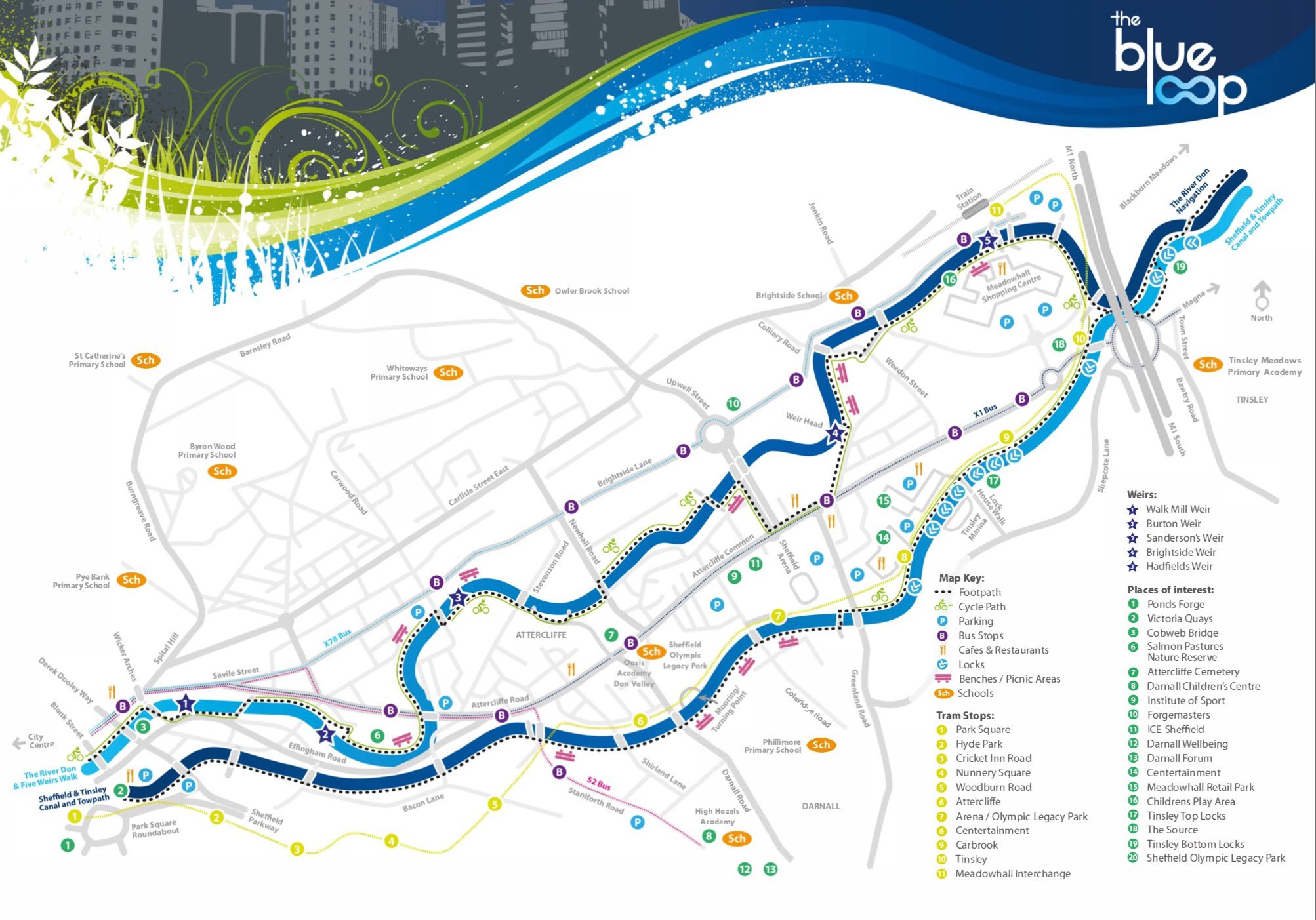
The piece of the canal that most people will know best is the basin; Victoria Quays. It has become somewhere people visit or hang out, and is a success - the old buildings are well maintained and its a pleasant spot, especially in the summer. There is a row of buildings, Merchants Terrace, which are very nice indeed and where you could easily feel that you are stood in a different time. This success in protecting the heritage of the canal extends to the rest of the route - it wasn’t very long ago that there wasn’t the easy access along the towpath that exists today, and that it looked more like post-industrial wasteland rather than the green and interesting walk that it has become. Several groups and organisations have contributed to that maintenance, and we now have the ‘Blue Loop’ bringing together the River Don and the Sheffield and Tinsley Canal. This rather appropriately brings history full circle from the early efforts to navigate the Don, and then to build the canal - which finally connected Sheffield by water to the outside world.
As a child in the 1960s, I and my family spent a great deal of time on the canals, which were of course much quieter in those days. (My parents bought a part-built boat and made it habitable.) We even saw the last of the working boats occasionally.
Things have changed beyond recognition now, and an enormous amount of work, especially by volunteers, has opened up a huge mileage of once derelict canals, and many lengths of the more popular canals can become quite clogged with holidaymakers. I honestly have very mixed feelings about how popular canals have become.
We never made it to this part of the world, but I now feel inspired to walk along the towpath of this and the two sections of the Chesterfield canal.
Great stuff as always Calvin. Interested in the Worksop Road aqueduct. I note in Fairbanks plan the intention seemed to be for the road to go over the canal