


Meers Brook - The small great divide
Sheffield's hidden ancient boundary

A somewhat hidden Sheffield river may be the most historically significant. Stand on the bridge over the River Sheaf on Saxon Road just off Chesterfield Road, and you can see the arched entrance to a culvert that forms the confluence with the Meers Brook. A short urban river, with a name that means ‘boundary’, the Meers Brook separated Yorkshire and Derbyshire until 1900, and over a thousand years ago was part of the border dividing the Kingdoms of Mercia to the south and Northumbria to the north.
Originating as a series of small streams in Gleadless, the Meers Brook runs down into Cat Lane woods near the allotments, and then passes between the back gardens of Meersbrook Road and and Northcote Avenue. It is at the junction of these two roads, under a garage, that the brook rather unceremoniously disappears into a culvert. It then runs underground, under the roads and houses of Meersbrook, not to re-emerge until it joins the Sheaf between Saxon Road and Broadfield Road.
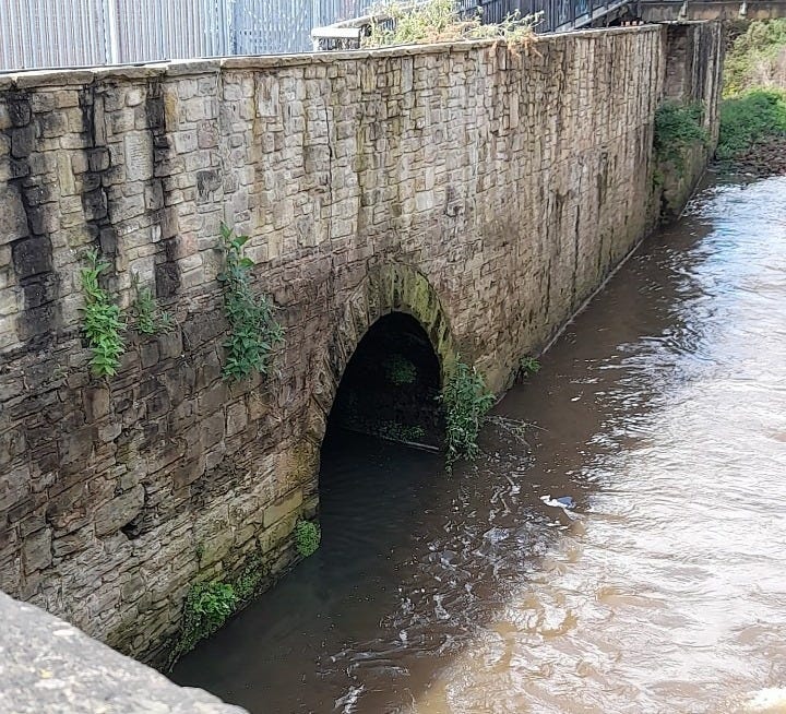
The Meers Brook emerging from the culvert alongside Saxon Road
This wasn’t an example of Victorian culverting as is often the case. The Meers Brook flowed past the houses and gardens of the area named after it until 1957. It was concealed (and slightly narrowed and straightened) as a flood prevention measure, having previously run free down the middle of the valley between Albert Road and Valley Road. The layout of the roads still give many indications of the original route (as does the topography of the area). The river ran under a bridge near the top of Albert Road and then dipped into the valley. It crossed Kent Road on the surface, cutting off the through road except by the crossing of a small footbridge.
Brooklyn (‘pretty brook’) Road still has a tell-tale gap in the houses where the water used to be. Originally the road only ran as far as the river from the Albert Road side, and even today nearby Molloy Street comes to a sudden end where the river formerly ran. There are other clues to the past too. On the pre-1900 Sheffield side of the brook are Carrfield Road and Drive, whereas on the old Derbyshire side the spelling is a single ‘r’ in Carfield Lane and Avenue. These are different spellings of the same word meaning boggy or wet ground; one preferred in Yorkshire and the other in Derbyshire.
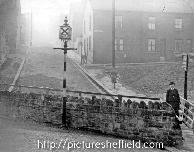
Kent Road footbridge across the Meers Brook (Rushdale Avenue in the background)
There was even enough of a flow to have water power on the Meers Brook; Blythe Wheel, owned by the family that were long-standing early occupants of Bishops House, stood close to where Rushdale Terrace is today. It was last in recorded use around 1740, and probably used for corn milling or grinding. The ‘breakback’, a surviving long footpath off Argyle Road just opposite Skelton Road, was part of the original walk from Bishops House down to the Blythe Wheel. Later several other modern industries were established close to the river, some of which remain today along Valley Road. A late 19th century tannery building still stands on the corner with Chesterfield Road, and tanning was a filthy industry that would have made good use of such a ready water supply.
Like the Megatron under Sheffield station, the Meers Brook attracts urban explorers (you can find their photos and films online). It is possible to access and traverse the whole length of the culvert. It is only four or five feet high much of the way though, with just occasional places where you can stand up and stretch. I’ve been through the full length of the culvert a few times, and one of the great features is that several road bridges are still intact, built into the structure. A couple are modern, but the 18th century pack bridge under Chesterfield Road is still there, entombed in mid-20th century concrete.
With the current enthusiasm for ‘daylighting’ culverted rivers I wonder if the lower part of the Meers Brook will ever return to the surface, at least in part? Flood prevention measures have changed over the years. The stretch of the brook in Cat Lane woods is still an attractive view as it disappears behind the houses, and if uncovered it would make a nice feature further downstream too. This narrow strip of water that used to divide Yorkshire from Derbyshire, and once separated two historic Kingdoms, will have to remain in hiding until then.
It’s astonishing that such small brooks formed part of the border between these ancient kingdoms. I wonder if they were once much larger, or whether perhaps there are so many water courses streaming off the Peaks that it just depended where the local powers stationed their soldiers. It may also have been that it was the valleys rather than the brooks themselves which proved easier to defend.
I understand that Dore (“gateway”?), through which the Sheaf runs, was a meeting point between the respective kings of Northumbria/Deira and Mercia when they wanted to parley.
I’ve found the boundary of York Bishopric at the time of Offa
https://en.m.wikipedia.org/wiki/File:England_diocese_map_Offa.svg
It’s boundary looks like it follow watercourses
Post 950ad the bishopric was extended into Nottinghamshire
https://commons.wikimedia.org/wiki/File:England_diocese_map_post_950.svg
Like a finger poking the south of England