
Mapping Sheffield
From town plans to the Ordnance Survey

(This post was originally issued to paid subscribers in September 2025)
I suspect we all like old maps. Anyone with an interest in the history and heritage of their town or city, or even neighbourhood, will have had their eye caught by old maps of the area. What is shown, what’s there and what’s not there, the names that have survived, and those that have changed - all are fascinating to see. Before we had photographs we only had writing and mapping to record on paper what places looked like. It isn’t just what is shown on the maps though, but also the evolution of maps themselves - early maps (or plans) were usually about property ownership, disputes, or the purchase of land. Those maps tended to be commissioned by people who had a financial interest in the area depicted. Within half a century though mapping was being transformed into that we recognise and still use today.
Sheffield has a great collection of eighteenth century plans carried out by the Fairbank family of surveyors. These plans are of varying quality and interest - some are of a single field or property boundary, but some are a vital piece of evidence of the past use of areas of Sheffield now much changed. The Fairbanks also produced plans of the town centre, recognisable street maps, from 1771 onwards. These added to the knowledge provided by the 1736 Gosling Town Plan that I have previously taken a look at - that was the first map of the town centre, or at least the earliest to survive. Into the nineteenth century the publishers of town directories would often produce a map to accompany the lists of street names and businesses; maps for people who wanted to know where places were, rather than being about who owned the land.
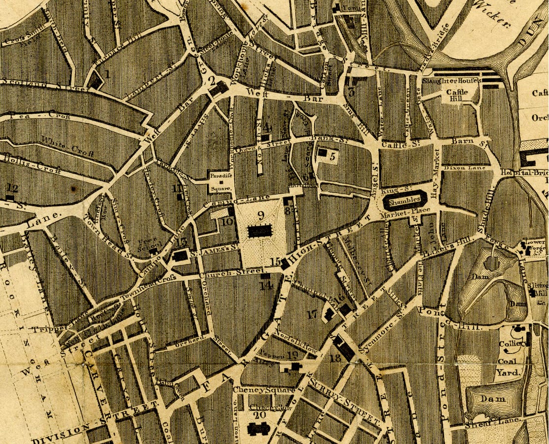
Fairbank’s 1797 town plan
I’m going to take a closer look at the old town centre as it appeared on five maps between 1797 and 1855 (links to the full sized images are at the bottom of the page). The first above is from the Fairbank plan of 1797 - it is an extract, but one difference between the maps is that the earlier ones only covered the town centre. It’s interesting how far that centre extended as time goes on. It is a street map, different to most Fairbank plans which were often primarily concerned with property boundaries. The map employed a numbering index for places of interest, with no.9 here being the present-day cathedral, and no.15 the old Town Hall on the corner of the church grounds (before the current ‘old’ Town Hall on Waingate which was built in 1808).
The first half of the nineteenth century saw several different surveyors have maps of Sheffield published. In 1823 John Leather mapped the town centre, apparently for its inclusion in a book released the following year, ‘The Picture of Sheffield’. Leather’s map is clearer and bolder, more clearly a street map as we would recognise it. He uses another numbering system, this time with the cathedral site given no.1. Many eyes I suspect will be drawn to the very familiar layout and street names of the old town centre - many of the buildings may come and go, but names are very durable things. On both maps we can see the River Sheaf running in the open, with the associated dams clustered around the station site; the ‘ponds’ area was indeed well named.
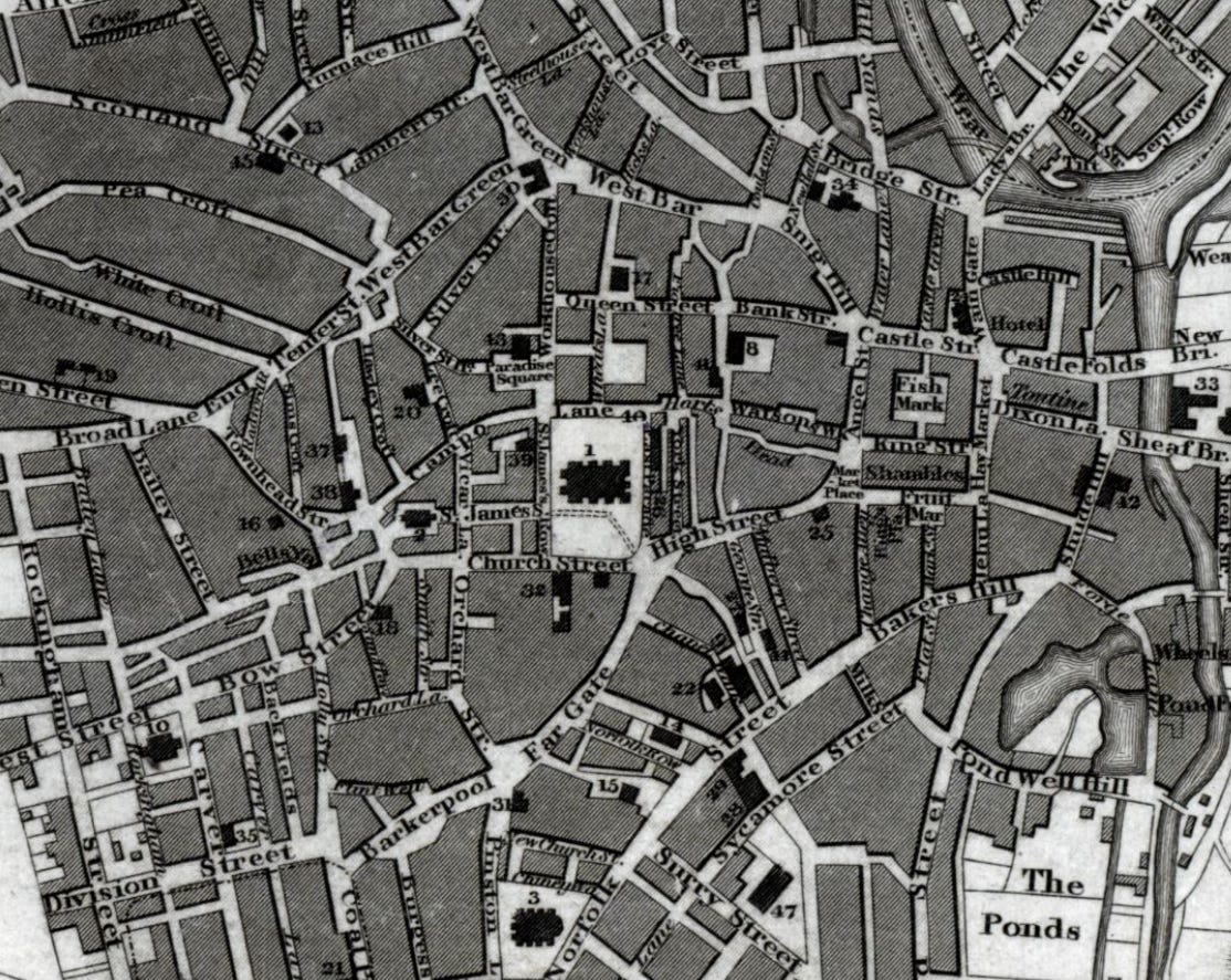
The 1823 Leather map
The maps from this time included areas marked with ‘proposed street’ or ‘building ground’ or similar. The expanding town was not only recorded, but planned future changes are there as well. Another surveyor to leave his mark on the map history of the town was J. Tayler in 1832. His map extends to Pitsmoor, to part of Attercliffe, and out into Ecclesall. It is described as being a ‘Map of the town and environs of Sheffield’ - taking in more area than most earlier maps of the town. Heading towards Hillsborough the map ends at the old barracks, next to the present-day Barrack Lane (as does the Leather map). Tayler’s map is in a different style, not withstanding the poorer quality of the image - the street layout has become less clear again.
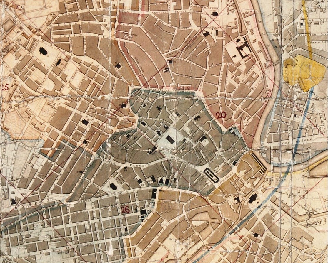
Tayler’s map of ‘Sheffield and environs’ in 1832
The late eighteenth and early nineteenth centuries saw several directories of the old town, as well as the more regular appearance of new maps. The directories grew from the lists of names and addresses to include lengthy histories and descriptions of the area too. One of the notable such publications were those of William White, whose 1838 edition included a very interesting account of the town at the time as well as his new map. White’s company went on to publish directories of towns and cities across the country, but he was born in Sheffield and learnt the trade under another Yorkshire surveyor Edward Baines (who had produced his own Sheffield map in 1822). White’s 1838 map includes the brand new Wicker Station, Sheffield’s earliest - and likely recorded by the surveyor before it opened to the public on October 31st that year.
The 1845 White’s Sheffield directory is available online here;
https://archive.org/details/generaldirectory00whit/mode/2up
White’s 1838 map (Wicker Station top right)
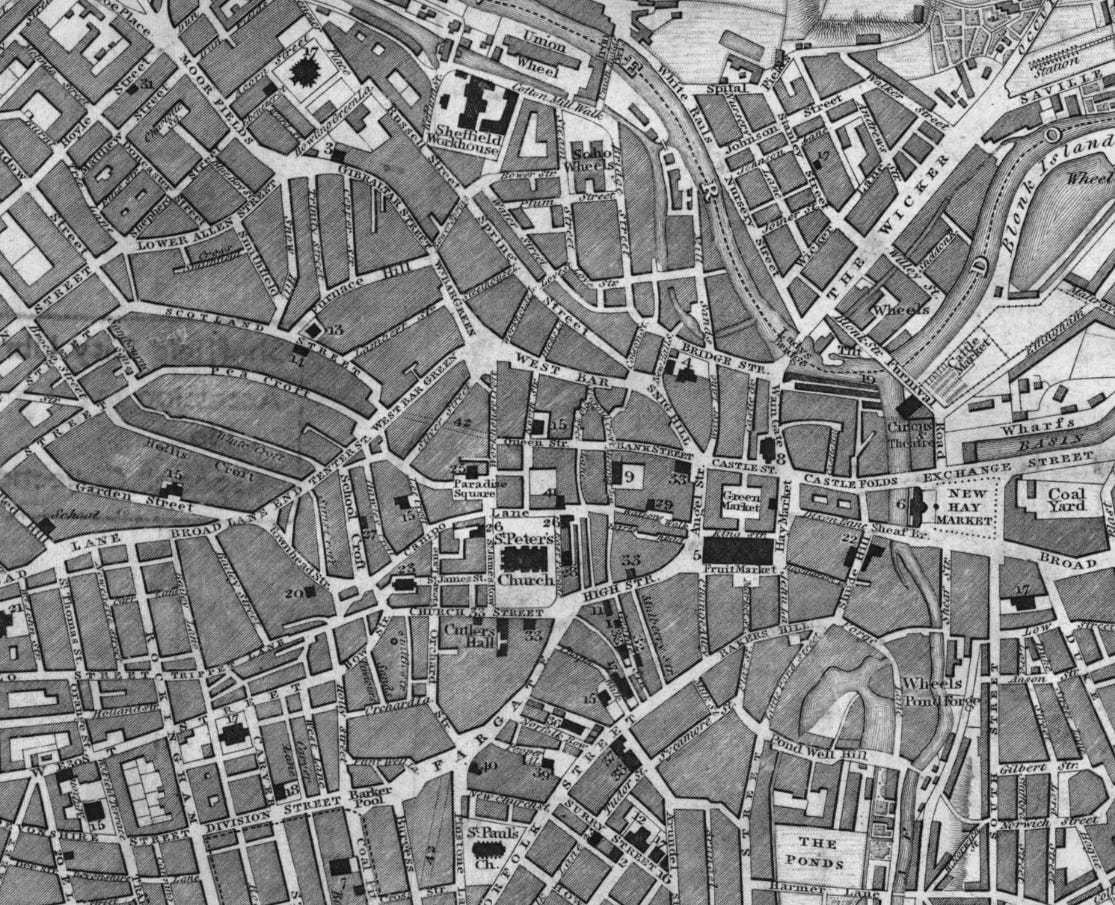
The mapping of Sheffield (and the rest of the UK) was greatly enhanced by the appearance of the six-inch Ordnance Survey map - with a similar look to the OS map we use today. There had been earlier OS maps with smaller scale and detail, but in 1855 the six-inch map of Sheffield was published and the game changed. It was surveyed over a period of around four years, often quoted as having been originally surveyed in 1850/51. There must have been changes over the time it took - this was certainly a time of expansion and development in the town. Some of the most marked differences between the OS map and its predecessors are on the outskirts, with more detail of rivers and industrial workings for example. Here in the town centre though there is a big change; all the buildings are marked out, not just the important ones.
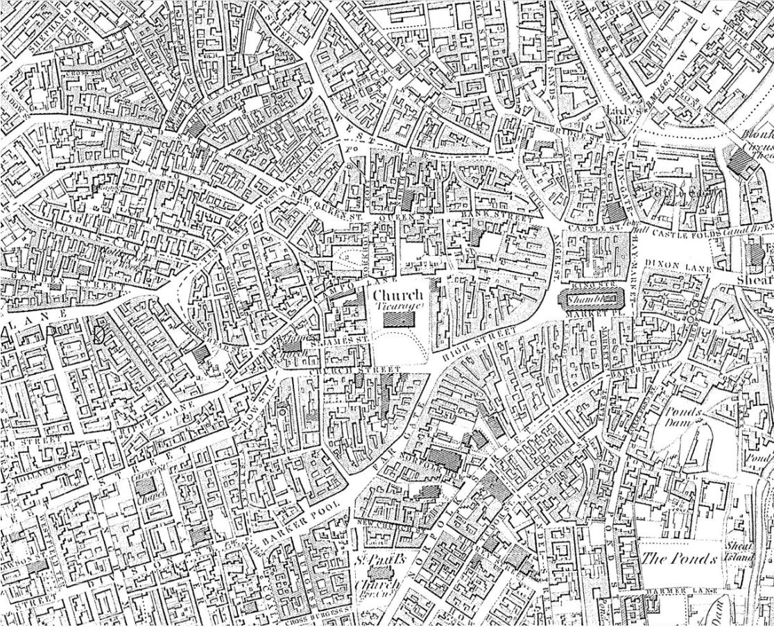
The first six-inch OS map of Sheffield published in 1855
The 1855 Ordnance Survey is a superb and very important map. It has been useful for so many reasons in my various work and projects - not least because it is right at the time that most interests me in Sheffield history. Without it we would know much less about the lost industrial tramways that I am interested in, and the 1830s water works conduit too. It places lost parts of the city far more precisely than the earlier plans did. I definitely recommend a closer look - there is so much to get lost in! Usefully White’s published two revised editions of the OS map, in 1863 and 1873, and these show plenty of changes across the three dates too.
We live in a time of extraordinary advances in mapping - the range and quality, but also the easy access and availability. Google Earth and Street View are incredibly interesting and useful, and impossible to have imagined just twenty years ago. Future generations of historians and enthusiasts will have so much detail about our lives at their fingertips. However I don’t think they will quite experience the excitement and occasional air of mystery that an Ordnance Survey map provides; identifying symbols, seeing words like ‘disused’, ‘abandoned’, ‘dismantled’, and wondering what will be found on the ground - all the joys of the OS map. To virtually walk the streets of old Sheffield with our collection of old maps is a great thing indeed.
1797 map: https://picturesheffield.com/frontend.php?keywords=Ref_No_increment;EQUALS;y11284&pos=33&action=zoom&id=74020
1823 map: https://picturesheffield.com/frontend.php?keywords=Ref_No_increment;EQUALS;y09447&pos=20&action=zoom&id=63784
1832 map: https://picturesheffield.com/frontend.php?keywords=Ref_No_increment;EQUALS;arc01933&pos=24&action=zoom&id=72779
1838 map: https://picturesheffield.com/frontend.php?keywords=Ref_No_increment;EQUALS;arc01959&pos=18&action=zoom&id=23685
1855 map: https://picturesheffield.com/frontend.php?keywords=Ref_No_increment;EQUALS;y12744&pos=28&action=zoom&id=85365
1863 map: https://picturesheffield.com/frontend.php?keywords=Ref_No_increment;EQUALS;arc01960&pos=10&action=zoom&id=23686
1873 map: https://picturesheffield.com/frontend.php?keywords=Ref_No_increment;EQUALS;y09450&pos=14&action=zoom&id=63788
Great links - love maps. So useful when tracing family records and seeing where they lived - thank you